GRAN QUIVIRA   Inventory/Coordination


Site Inventory
<
Ruins
A mix of pit houses, pueblos and Spanish missions exist on the site. All have suffered greatly due to weather, archeological raiding and neglect. Archeological stabilization and protection is haphazard and unsightly. Changes to trail system needed to protect site.
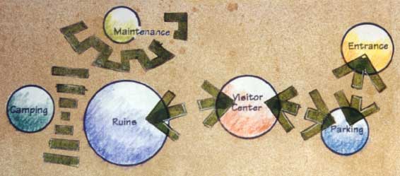
Visitor Center
Current Center is a converted residence. The internal layout is poor.

Topography
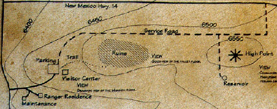
The site is dominated by a steep hill rising off the floor of a semi-arid valley. The major archeological features are located on top of this hill.

Flora/Fauna
Rattlesnakes present in high numbers. Imperative to keep visitors from wandering park grounds. Main vegetative cover is juniper and cholla cactus. No endangered species noted.

Parking
Cars, R/V's and buses share the same lot.

Climate
Semi-arid region. Great deal of daily and seasonal variation. Little rainfall but lightning and wind storms. Can be dangerous due to exposure.

Trails
Crushed limestone trail system. At times very steep. No method to keep visitors from accessing more sensitive areas of the ruins.

Views
Parking/Visitor Center:
 Dramatic view of the Mission ruins.
Site High Point:
 Commanding view of Pueblo/Mission ruins and valley. There can be an uncomfortable exposed feeling especially during hot, cold or storm conditions.
From the Ruins area:
 Good view of the valley floor. There is an uncomfortable, exposed feeling especially during hot, cold or storm conditions.


Program Inventory
NATIONAL PARK SERVICE DEVELOPMENT GUIDELINES
  • Facilities function within surrounding ecosystem minimizing stresses on resources and processes.
  • Carrying capacity based on capability and resiliency of natural resources not on physical capacity to contain development.
  • Indicator species identified and monitored.
  • LIMITS of acceptable environmental change established prior to development.
  • Effect of development on resources routinely monitored, evaluated and problems corrected.
  • Fragmentation of habitats and loss of biological diversity avoided.
  • Transition zones considered and implemented as needed.
  • Long term resource protection on regional scale.
PROGRAM ELEMENTS SPECIFIC TO GRAN QUIVIRA
  • Increase interpretive opportunities
    Increase sense of connection between past and present.
    Articulate impact of older cultures on the land.
    Educate public on importance of not disturbing ruins.
  • Emphasize impact of views.
  • Institute sustainable growth practices into current site activities. Include these practices in any new construction.
  • New construction to follow contours and preserve existing land patterns.
  • Trail system should control access to ruins.
  • Parking to provide better distinction of car and R/V spaces.
  • Renovate, expand or replace existing visitor center.
  • PROVIDE for overnight camping.

Coordination
  • Heighten visitor appreciation of the Ruins. Use space within Ruins to emphasize need of all peoples for control of environment Incorporate topography and sequential movement to increase visual significance of the Ruins.
  • Establish visual/access links between day use facilities.
  • Allow visual links between Ruins and Camping Area. Do not permit direct access to reduce potential vandalism/misuse of Ruins at night.
  • Limit visual impact of maintenance areas.
  • Gran Quivira
    Background | Inventory/Coordination | Process | Concept 
     Master Plan | Details | Sketches
    Riparian Preserve | Louisana Research Park
    Construction | Graphics | Planting Design
    Portfolio Page
    toneylowery@yahoo.com